Help fuel the next Guelph Map:
Never miss a Guelph Map:
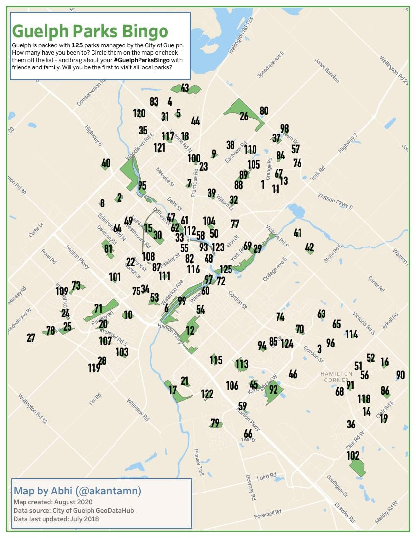
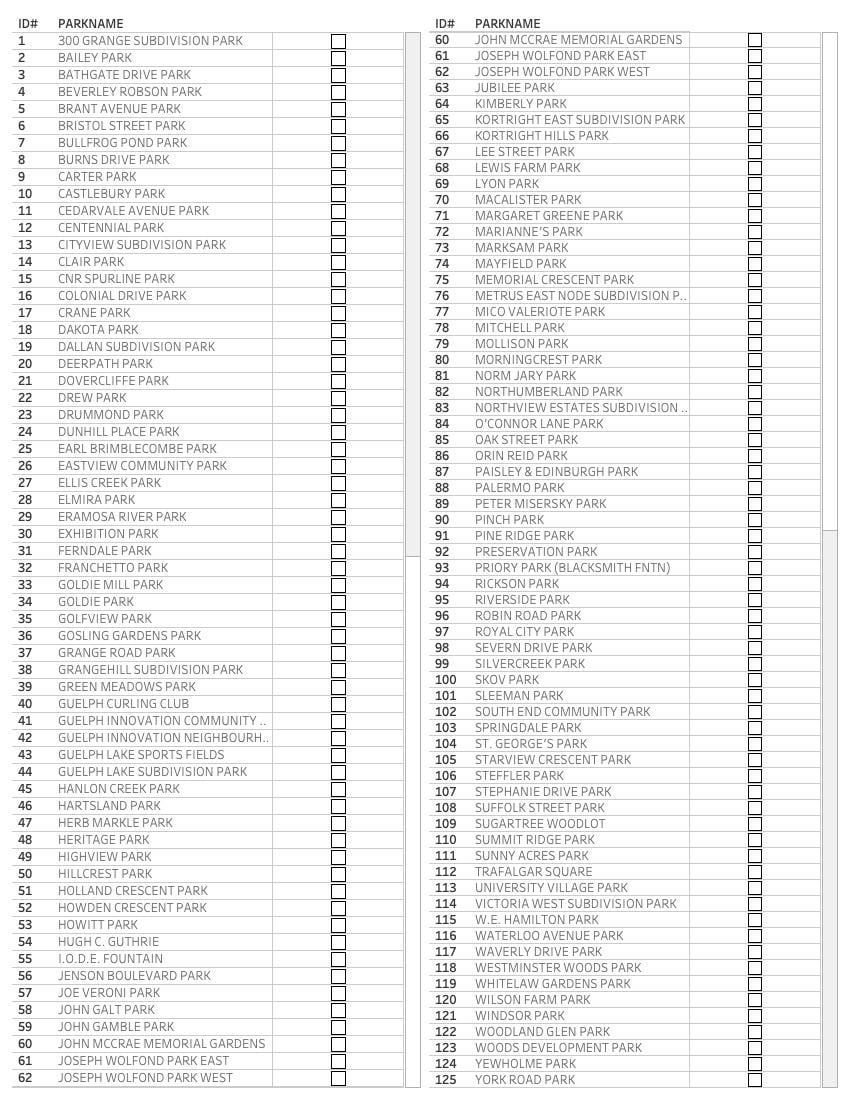
There are 125 parks managed by the City of Guelph. Make it your goal to visit them all! Section 1: Interactive map of all parks + printable map and checklist of all parks
All you need are these +12 maps, each a route is under 10kms that loops around so you can get back to where you started. Most of the routes take you through neighbourhoods and sidewalks that should be accessible even in the winters. Section 2: All parks broken down into 12 walkable/bikeable routes.
But if you are looking specifically for parks and trails that are open all season, you should go here: Section 3: Winter accessible parks and trails
Maps were originally shared on Guelph This and That – “Guelph’s Online Neighborhood” . Printable version: http://bit.ly/GuelphParksMaps
All Parks
Interactive map + Printable Map + Printable Checklist
High Quality pdf: http://bit.ly/GuelphParksBingo
Walkable Maps
12 maps, each a <10km loop.
Map 01 | Onward Willow Loop | 6.6 kms
Open in Google Maps: https://goo.gl/maps/FgHf7H2LvNVoTe596
Map 02 | Springdale Park Loop – West End | 6.2 kms
Open in Google Maps: https://goo.gl/maps/BtFp5gBbaP5tuw4k8
Map 03 | Brant Park Loop – East End | 6.6 kms
Open in Google Maps: https://goo.gl/maps/mstXCfNqAtZfZeRd6
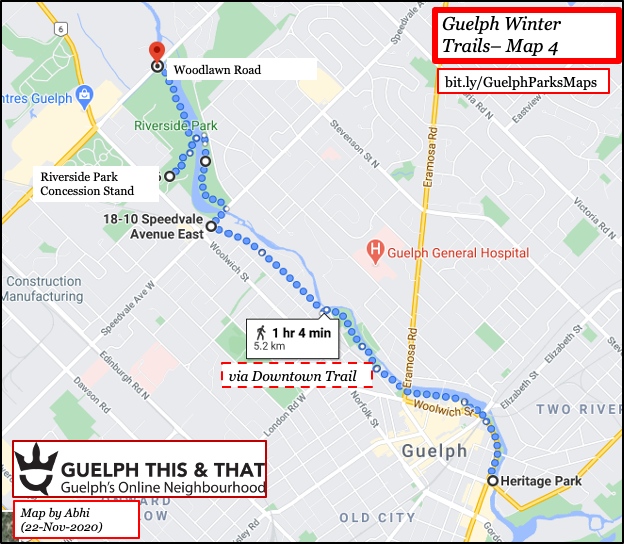
Map 04 | Riverside Park Loop | 7.7 kms
Open in Google Maps: https://goo.gl/maps/ZPjujC5avfiGAKyZ8
Map 05 | Margaret Green Park | 7.6 kms
Open in Google Maps: https://goo.gl/maps/vMWGg7Rm65otBqTw7
Map 06 | Speed River Loop | 7.3 kms
Open in Google Maps: https://goo.gl/maps/xsp1sFfGnECMFAWH6 |
Map 07 | East End Loop | 5.6 kms
Open in Google Maps: https://goo.gl/maps/BVGVYmVPPkHb1i3b6
Map 08 | Vic Rec Center Loop | 9.1 kms
Open in Google Maps: https://goo.gl/maps/ZVncUa6dnuJoQxf49
Map 09 | Exhibition-Downtown Loop | 7 kms
Open in Google Maps: https://goo.gl/maps/NsBi6qwxTRkFJzk57
Map 10 | South End Loop | 5.6 kms
Open in Google Maps: https://goo.gl/maps/NjfgPfWuuzS7TkPd8
Map 11 | Preservation Park Loop | 8.8 kms
Open in Google Maps: https://goo.gl/maps/TatRHUXxL4GG8rvc7
Map 12 | Orin Reid Trail Loop | 6.1 kms
Open in Google Maps: https://goo.gl/maps/h2o8s89B5Dupptm28
Bonus | Smaller Summer Routes
https://goo.gl/maps/8R1tRzdwez89jp889 – 3 km 30 minutes – off-leash dog park loop
https://goo.gl/maps/W82M2pojKSUJKHKP9 – 4.5 kms 45 minutes (Bathgate drive loop with missing parks 65 and 114)
https://goo.gl/maps/VBA3y6bbA2dhWegA9 – 3.5 kms 45 minutes (Eramoa river park loop)
https://goo.gl/maps/VyKKVKv89caLbokj8 – 3.6 kms 45 minutes (Severen Drive Park)
Winter Trails Maps
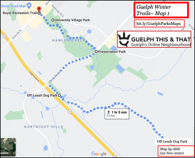
Map 1 | Dog Park – Stone Road Mall | 5.3 kms
https://goo.gl/maps/DRjUThcEF9otR9Pd8 |
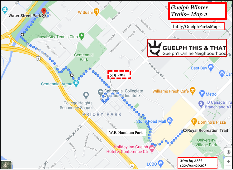
Map 2 | Stone Road Mall – Water Street Park | 3.9 kms
https://goo.gl/maps/tjJd4eiGXTWfQ6fK9 |
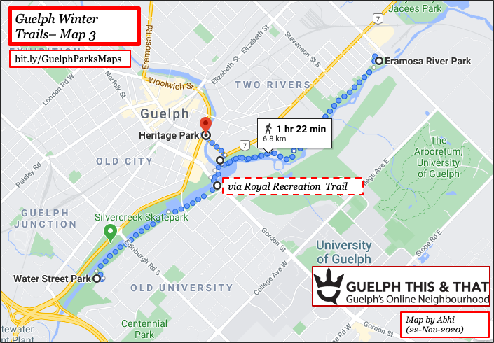
Map 3 | Water Street – Eramosa – Heritage Park | 6.8 kms
https://goo.gl/maps/QJsCbhH2diShrLi39 |
Map 4 | Heritage – Riverside Park – Woodlawn Rd | 5.2 kms
https://goo.gl/maps/a6mRiBo1ZEC1TdXK9 |